
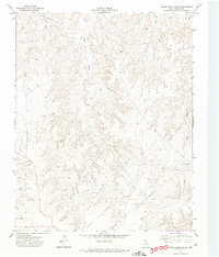
1972 Map of Miami
USGS Topo · Published 1974About this map
The town of Miami serves as the focal point of this Roberts County landscape, situated where the Atchison Topeka and Santa Fe railroad corridor meets the winding path of Red Deer Creek. In the early 1970s, the area's economy was a blend of traditional ranching and industrial development, evidenced by the expansive Quinpono Gas and Oil Field to the west and several Gravel Pits dotting the drainages. The terrain is defined by the sharp erosion of Bluff Creek and numerous unnamed draws that cut into the high plains.
Find a feature on this map
16 named features on this map. Tap any name to fly to it.
Don’t see what you’re looking for? This feature index may not catch every label — zoom into the map to look around manually.
Map Details
Editions of this 1972 Miami Map
This is the sole edition of this map. No revisions or reprints were ever made.
Other maps of this area

1954 · Amarillo
USGS Topo · 1:250,000

1958 · Amarillo
USGS Topo · 1:250,000

1966 · Laketon
USGS Topo · 1:24,000

1967 · Hoover
USGS Topo · 1:24,000

1967 · Tody School
USGS Topo · 1:24,000

1967 · Lora
USGS Topo · 1:24,000

1971 · Dry Creek SE
USGS Topo · 1:24,000

1972 · Washburn Arroyo
USGS Topo · 1:24,000

1972 · Pampa NE
USGS Topo · 1:24,000
1972 · Horse Creek South
USGS Topo · 1:24,000