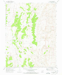
1969 Map of Dry Mesa
USGS Topo · Published 1978About this map
Dry Mesa and the plateau of Horse Heaven anchor this Emery County landscape as it was documented in the late 1960s. The terrain is defined by an intricate network of drainages, including Summerville Wash and its various branches, which carve through the high ground. Evidence of earlier industrial or transportation efforts is visible in the Old RR Grade, which runs through the western section of the map, sometimes followed by a Old RR Grade Jeep Trail. Water management for livestock or local needs is indicated by features like Saleratus Reservoir and Smith Pond. The presence of a lone Mine and a Test Hole suggests a history of mineral exploration in this arid reach of the state, while the Cement Crossing on Joe Hole Wash marks a specific point of passage in a road network otherwise dominated by rugged trails.
Find a feature on this map
29 named features on this map. Tap any name to fly to it.
Don’t see what you’re looking for? This feature index may not catch every label — zoom into the map to look around manually.
Map Details
Editions of this 1969 Dry Mesa Map
2 editions found
Other maps of this area

1886 · Price River
USGS Topo · 1:250,000

1896 · Price River
USGS Topo · 1:250,000

1948 · Woodside
USGS Topo · 1:62,500

1949 · Woodside
USGS Topo · 1:62,500

1950 · Woodside
USGS Topo · 1:62,500

1953 · Red Plateau SE
USGS Topo · 1:24,000

1953 · Beckwith Peak SW
USGS Topo · 1:24,000

1956 · Price
USGS Topo · 1:250,000

1960 · Price
USGS Topo · 1:250,000

1962 · Price
USGS Topo · 1:250,000