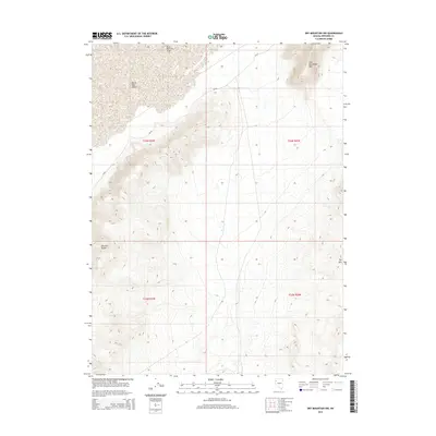
2014 Map of Dry Mountain NW
USGS Topo · Published 2014About this map
The Black Rock Desert dominates the northwestern portion of this Pershing County landscape, marking the transition from the expansive alkali flats to the high-elevation terrain of the Selenite Range. In the northeastern corner, the relief of Old Razorback Mtn rises sharply, while the southern reaches are defined by the slopes of Dry Mtn. This 2014 survey documents the isolated infrastructure of the region, including the Black Rock City Airport, which serves this remote corner of the Great Basin. Access is primarily dictated by state routes NV-49 and NV-48, which traverse the high desert floor near the desert's edge. The map provides a clear look at the Public Land Survey System grid, detailing the township and range boundaries that organize this largely uninhabited territory.
Find a feature on this map
11 named features on this map. Tap any name to fly to it.
Don’t see what you’re looking for? This feature index may not catch every label — zoom into the map to look around manually.
Map Details
Editions of this 2014 Dry Mountain NW Map
This is the sole edition of this map. No revisions or reprints were ever made.
Other maps of this area

1886 · Granite Range
USGS Topo · 1:250,000

1894 · Granite Range
USGS Topo · 1:250,000

1955 · Lovelock
USGS Topo · 1:250,000

1959 · Lovelock
USGS Topo · 1:250,000

1964 · Gerlach
USGS Topo · 1:62,500

1980 · Dry Mountain NW
USGS Topo · 1:24,000

1980 · Eagle Rock Spring
USGS Topo · 1:24,000
1980 · Trego Hot Spring
USGS Topo · 1:24,000

1980 · Dry Mountain
USGS Topo · 1:24,000

1980 · Tenmile
USGS Topo · 1:24,000