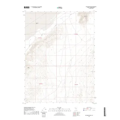
2018 Map of Dry Mountain NW
USGS Topo · Published 2018About this map
The Black Rock Desert landscape dominates the northern section of this Pershing County survey, illustrating the stark topography of the Great Basin. To the east and south, the terrain rises sharply into prominent peaks, including Old Razorback Mtn and Dry Mtn. These mountain masses are separated by alluvial flats and corridors that have long dictated movement through this arid environment. A primary route, Jungo Rd, cuts across the northern basin, tracing a path that has historically connected isolated mining and ranching outposts. Along the western edge, the foothills of the Selenite Range provide a dramatic contrast to the flat desert playa. This map provides a clear record of the Public Land Survey System divisions, marking the township and range boundaries that define land ownership and management in the Nevada high desert.
Find a feature on this map
9 named features on this map. Tap any name to fly to it.
Don’t see what you’re looking for? This feature index may not catch every label — zoom into the map to look around manually.
Map Details
Editions of this 2018 Dry Mountain NW Map
This is the sole edition of this map. No revisions or reprints were ever made.
Other maps of this area

1886 · Granite Range
USGS Topo · 1:250,000

1894 · Granite Range
USGS Topo · 1:250,000

1955 · Lovelock
USGS Topo · 1:250,000

1959 · Lovelock
USGS Topo · 1:250,000

1964 · Gerlach
USGS Topo · 1:62,500

1980 · Dry Mountain NW
USGS Topo · 1:24,000

1980 · Eagle Rock Spring
USGS Topo · 1:24,000
1980 · Trego Hot Spring
USGS Topo · 1:24,000

1980 · Dry Mountain
USGS Topo · 1:24,000

1980 · Tenmile
USGS Topo · 1:24,000