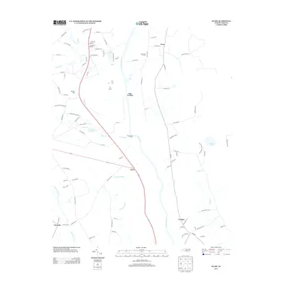
2013 Map of Duart
USGS Topo · Published 2013About this map
The Cape Fear River serves as the central artery for this region of eastern North Carolina, where river landings once anchored local commerce and transit. Tolar Landing and Prospect Hall Landing sit along its banks, marking points of historical significance for river navigation. To the west, the landscape is defined by extensive lowlands and drainage systems, including Goodman Swamp, Gallberry Swamp, and the Big Swamp Canal.
Find a feature on this map
93 named features on this map. Tap any name to fly to it.
Don’t see what you’re looking for? This feature index may not catch every label — zoom into the map to look around manually.
Map Details
Editions of this 2013 Duart Map
This is the sole edition of this map. No revisions or reprints were ever made.
Other maps of this area

1953 · Florence
USGS Topo · 1:250,000

1954 · Florence
USGS Topo · 1:250,000

1955 · Elizabethtown
USGS Topo · 1:62,500

1957 · Bladenboro
USGS Topo · 1:62,500

1959 · Roseboro
USGS Topo · 1:62,500

1959 · Saint Pauls
USGS Topo · 1:62,500

1982 · Elizabethtown
USGS Topo · 1:100,000

1986 · Tar Heel
USGS Topo · 1:24,000
1986 · Hope Mills
USGS Topo · 1:24,000
1986 · Northeast Lumberton
USGS Topo · 1:24,000