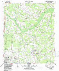
1986 Map of Northeast Lumberton
USGS Topo · Published 1987About this map
The northeastern outskirts of Lumberton reveal a landscape where suburban growth meets the intricate drainage of the coastal plain. In the mid-1980s, this area was defined by its educational and religious hubs, including the Robeson Tech Inst and Littlefield High Sch, alongside numerous country churches such as Tenmile Ch, Barkers Ch, and Floyd Temple Ch. The CSX rail line cuts through the northwestern corner, passing near settlements like Powers and the Thomas Cem.
Find a feature on this map
48 named features on this map. Tap any name to fly to it.
Don’t see what you’re looking for? This feature index may not catch every label — zoom into the map to look around manually.
Map Details
Editions of this 1986 Northeast Lumberton Map
This is the sole edition of this map. No revisions or reprints were ever made.
Other maps of this area

1953 · Florence
USGS Topo · 1:250,000

1954 · Florence
USGS Topo · 1:250,000

1957 · Bladenboro
USGS Topo · 1:62,500

1959 · Saint Pauls
USGS Topo · 1:62,500

1972 · Northwest Lumberton
USGS Topo · 1:24,000

1972 · Southwest Lumberton
USGS Topo · 1:24,000

1972 · Rennert
USGS Topo · 1:24,000
1976 · Southwest Lumberton
USGS Topo · 1:24,000
1976 · Rennert
USGS Topo · 1:24,000
1976 · Northwest Lumberton
USGS Topo · 1:24,000