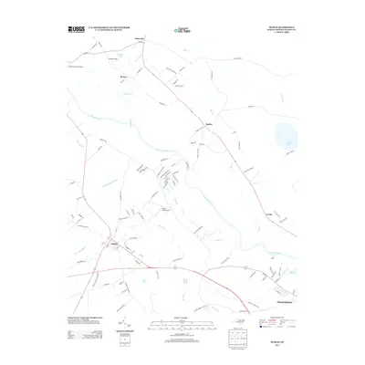
2013 Map of Dublin
USGS Topo · Published 2013About this map
The Cape Fear River winds through the heart of this Bladen County landscape, serving as the central geographic feature between the settlements of Dublin and Ruskin. The terrain is defined by a series of Carolina bays and wetlands, including McNeil Bay, Sheriff White Bay, and the expansive Reedy Meadow Swamp. These natural depressions, combined with smaller tributaries like Harrison Cr and Ellis Cr, dictate the rural road patterns and agricultural footprints of the early 21st century.
Find a feature on this map
106 named features on this map. Tap any name to fly to it.
Don’t see what you’re looking for? This feature index may not catch every label — zoom into the map to look around manually.
Map Details
Editions of this 2013 Dublin Map
This is the sole edition of this map. No revisions or reprints were ever made.
Other maps of this area

1953 · Florence
USGS Topo · 1:250,000

1954 · Florence
USGS Topo · 1:250,000

1955 · Elizabethtown
USGS Topo · 1:62,500

1957 · Bladenboro
USGS Topo · 1:62,500

1959 · Roseboro
USGS Topo · 1:62,500

1959 · Saint Pauls
USGS Topo · 1:62,500

1982 · Elizabethtown
USGS Topo · 1:100,000

1986 · Tar Heel
USGS Topo · 1:24,000
1986 · Bladenboro
USGS Topo · 1:24,000
1986 · Duart
USGS Topo · 1:24,000