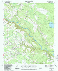
1987 Map of Dublin
USGS Topo · Published 1987About this map
The Cape Fear River carves a winding path through this corner of Bladen County, defining a landscape of dense swamps and unique Carolina bays. In the 1980s, the community of Dublin served as a central hub, flanked by the Bladen Technical Institute and a network of rural congregations including Shiloh Ch and McCord Ch. The geography is characterized by numerous elliptical depressions or "bays," such as Sheriff White Bay, McNeil Bay, and Salters Lake, many of which are preserved within the Jones Lake State Park and the expansive Bladen Lakes State Forest. Evidence of earlier transport persists via the Old Railroad Grade cutting through the Bear Ford Swamp toward Elizabethtown. This survey documents a rural economy where large-scale drainage features like Beaver Dam Swamp and Reedy Meadow Swamp coexist with small settlements like White Oak and Ruskin.
Find a feature on this map
52 named features on this map. Tap any name to fly to it.
Don’t see what you’re looking for? This feature index may not catch every label — zoom into the map to look around manually.
Map Details
Editions of this 1987 Dublin Map
This is the sole edition of this map. No revisions or reprints were ever made.
Other maps of this area

1953 · Florence
USGS Topo · 1:250,000

1954 · Florence
USGS Topo · 1:250,000

1955 · Elizabethtown
USGS Topo · 1:62,500

1957 · Bladenboro
USGS Topo · 1:62,500

1959 · Roseboro
USGS Topo · 1:62,500

1959 · Saint Pauls
USGS Topo · 1:62,500

1982 · Elizabethtown
USGS Topo · 1:100,000

1986 · Tar Heel
USGS Topo · 1:24,000
1986 · Bladenboro
USGS Topo · 1:24,000
1986 · Duart
USGS Topo · 1:24,000