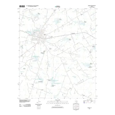
2010 Map of Dublin
USGS Topo · Published 2010About this map
The community of Dublin serves as the central hub of this agricultural landscape in central Texas, surrounded by smaller settlements like Cottonwood, Harbin, and Shiloh. The map reveals a highly managed watershed characterized by a dense network of water control structures, including Green Creek Dam Number 6 through Green Creek Dam Number 11 and numerous Soil Conservation Service reservoirs. These features illustrate the local priority of water management and flood control across the drainage basins of Resley Creek, Kirkendell Creek, and the North Fork Little Green Creek. Historical and social landmarks are visible at Live Oak Cemetery and Old Dublin Memorial Park, while the Dublin Municipal Airport and a network of Farm to Market roads like FM 219 and FM 847 define the modern transportation infrastructure. To the southeast, the crossroads of Purves anchors the landscape near the Sawyer Branch.
Find a feature on this map
70 named features on this map. Tap any name to fly to it.
Don’t see what you’re looking for? This feature index may not catch every label — zoom into the map to look around manually.
Map Details
Editions of this 2010 Dublin Map
This is the sole edition of this map. No revisions or reprints were ever made.
Other maps of this area

1888 · Hamilton
USGS Topo · 1:125,000

1890 · Stephenville
USGS Topo · 1:125,000

1894 · Hamilton
USGS Topo · 1:125,000

1920 · Stephenville
USGS Topo · 1:125,000

1954 · Brownwood
USGS Topo · 1:250,000

1954 · Abilene
USGS Topo · 1:250,000

1956 · Gustine
USGS Topo · 1:62,500

1956 · Hico
USGS Topo · 1:62,500
1956 · Proctor
USGS Topo · 1:24,000
1956 · Edna Hill
USGS Topo · 1:24,000