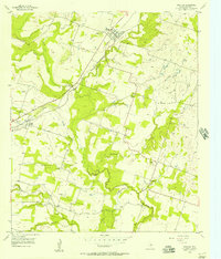
1956 Map of Proctor
USGS Topo · Published 1957About this map
Proctor and Hasse anchor this mid-1950s survey of Comanche County, where the agricultural landscape is defined by the winding course of the Leon River. The transportation network centers on the Gulf Colorado and Santa Fe (A T & S F) railroad, which passes through the heart of Proctor. This era shows a transition in rural education and social centers, evidenced by the Hasse Sch (Abnd) label, indicating the consolidation or closure of local schools.
Find a feature on this map
23 named features on this map. Tap any name to fly to it.
Don’t see what you’re looking for? This feature index may not catch every label — zoom into the map to look around manually.
Map Details
Editions of this 1956 Proctor Map
2 editions found
Other maps of this area

1888 · Hamilton
USGS Topo · 1:125,000

1889 · Brownwood
USGS Topo · 1:125,000

1890 · Stephenville
USGS Topo · 1:125,000

1894 · Hamilton
USGS Topo · 1:125,000

1894 · Eastland
USGS Topo · 1:125,000

1894 · Brownwood
USGS Topo · 1:125,000

1920 · Stephenville
USGS Topo · 1:125,000

1954 · Brownwood
USGS Topo · 1:250,000

1954 · Abilene
USGS Topo · 1:250,000

1956 · Gustine
USGS Topo · 1:62,500