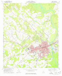
1974 Map of Dublin
USGS Topo · Published 1977About this map
Dublin and East Dublin are separated by the winding course of the Oconee River in this mid-1970s survey. The city serves as a regional hub of transportation and medicine, centered around a dense grid of streets featuring the Courthouse, City Hall, and Laurens Memorial Hospital. The surrounding countryside reveals a landscape defined by creeks such as Hunger and Hardship Creek and Strawberry Creek, where rural community life is anchored by small churches like Holly Grove Ch and Bethsaida Ch. Significant industrial and infrastructure elements are visible, including the Seaboard Coast Line and Central of Georgia railroads, along with the extensive grounds of the Veterans Hospital. To the north and west, the terrain transitions into agricultural land dotted with local landmarks like the Dublin Municipal Airport and the Dublin County Club.
Find a feature on this map
52 named features on this map. Tap any name to fly to it.
Don’t see what you’re looking for? This feature index may not catch every label — zoom into the map to look around manually.
Map Details
Editions of this 1974 Dublin Map
2 editions found
Other maps of this area

1957 · Macon
USGS Topo · 1:250,000

1958 · Macon
USGS Topo · 1:250,000

1964 · Macon
USGS Topo · 1:250,000

1974 · Cow Hell Swamp
USGS Topo · 1:24,000

1974 · Rentz
USGS Topo · 1:24,000

1974 · Dudley
USGS Topo · 1:24,000

1974 · East Dublin
USGS Topo · 1:24,000
1974 · Nicklesville
USGS Topo · 1:24,000
1974 · Dexter
USGS Topo · 1:24,000

1974 · Lovett
USGS Topo · 1:24,000