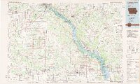
1984 Map of Dubuque South
USGS Topo · Published 1985About this map
The Mississippi River valley anchors this mid-1980s landscape, serving as both a state boundary and a corridor for the Chicago Milwaukee St Paul and Pacific railroad. Along its banks, the Upper Mississippi River Wild Life and Fish Refuge spans the river islands, while the sprawling Savanna Army Depot occupies the Illinois side. Settlement patterns in eastern Iowa reflect a mix of river-town commerce and inland agricultural centers, from the industrial presence of Dubuque to smaller villages like St Donatus and La Motte.
Find a feature on this map
99 named features on this map. Tap any name to fly to it.
Don’t see what you’re looking for? This feature index may not catch every label — zoom into the map to look around manually.
Map Details
Editions of this 1984 Dubuque South Map
4 editions found
Other maps of this area

1889 · Tipton
USGS Topo · 1:62,500

1890 · Tipton
USGS Topo · 1:62,500

1891 · DeWitt
USGS Topo · 1:62,500

1891 · Monticello
USGS Topo · 1:62,500

1891 · Maquoketa
USGS Topo · 1:62,500

1891 · Baldwin
USGS Topo · 1:62,500

1891 · Clinton
USGS Topo · 1:62,500

1892 · Wheatland
USGS Topo · 1:62,500

1892 · Goose Lake
USGS Topo · 1:62,500

1892 · Savanna
USGS Topo · 1:62,500