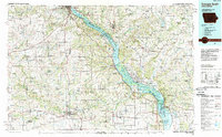
1984 Map of Dubuque South
USGS Topo · Published 1989About this map
The Mississippi River dominates this mid-1980s landscape, serving as a political and geographical divider between Iowa and Illinois. The riverfront is heavily managed, featuring the Upper Mississippi River Wild Life and Fish Refuge and the Savanna Army Depot along its eastern banks. Major hubs like Dubuque and Savanna anchor the river crossings, while the interior terrain is defined by dramatic elevations such as Table Mound and Pilot Knob.
Find a feature on this map
107 named features on this map. Tap any name to fly to it.
Don’t see what you’re looking for? This feature index may not catch every label — zoom into the map to look around manually.
Map Details
Editions of this 1984 Dubuque South Map
4 editions found
Other maps of this area

1889 · Tipton
USGS Topo · 1:62,500

1890 · Tipton
USGS Topo · 1:62,500

1891 · DeWitt
USGS Topo · 1:62,500

1891 · Monticello
USGS Topo · 1:62,500

1891 · Maquoketa
USGS Topo · 1:62,500

1891 · Baldwin
USGS Topo · 1:62,500

1891 · Clinton
USGS Topo · 1:62,500

1892 · Wheatland
USGS Topo · 1:62,500

1892 · Goose Lake
USGS Topo · 1:62,500

1892 · Savanna
USGS Topo · 1:62,500