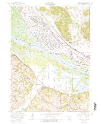
1953 Map of Green Island
USGS Topo · Published 1977About this map
The Savanna Army Depot Military Reservation dominates the landscape where the Apple River meets the Upper Mississippi River, showcasing a period of significant military presence along the tri-state border. This mid-century survey illustrates the intricate riverine environment of the Fish and Wild Life Refuge, a labyrinth of sloughs and lakes such as Crooked Slough and Snag Slough. The heavy rail traffic of the era is evidenced by the prominent lines of the Chicago Burlington and Quincy and the Chicago Milwaukee St Paul and Pacific, which intersect near the small settlement of Green Island. On the higher ground east of the wetlands, local life is anchored by family-named hollows and civic landmarks like the Lost Mound Sch and Reeceville Cem, providing a detailed view of Jackson County's rural infrastructure before modern consolidation.
Find a feature on this map
56 named features on this map. Tap any name to fly to it.
Don’t see what you’re looking for? This feature index may not catch every label — zoom into the map to look around manually.
Map Details
Editions of this 1953 Green Island Map
3 editions found
Other maps of this area

1892 · Savanna
USGS Topo · 1:62,500

1911 · Elizabeth
USGS Topo · 1:62,500

1911 · Galena
USGS Topo · 1:62,500

1913 · Galena
USGS Topo · 1:62,500

1935 · Miles
USGS Topo · 1:62,500

1936 · Elizabeth
USGS Topo · 1:62,500

1941 · Miles
USGS Topo · 1:62,500

1952 · Savanna
USGS Topo · 1:62,500

1953 · Blackhawk
USGS Topo · 1:24,000

1953 · Green Island
USGS Topo · 1:24,000