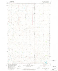
1982 Map of Duck Creek
USGS Topo · Published 1982About this map
Duck Creek and Lame Steer Creek carve through the landscape along the Montana-North Dakota border during the early 1980s. This survey, primarily covering the rugged eastern edge of Wibaux County, shows a rural economy centered on resource extraction and water management. Evidence of local infrastructure is found in the Landing Strips and a Gravel Pit, while Johnstone Dam manages the flow of the Lone Tree drainage. Numerous wells are dispersed across the township lines, indicating active land use in this borderland region. The map preserves the specific spatial relationship between Beach and the surrounding prairie as it was documented in the years following the mid-1970s field checks.
Find a feature on this map
10 named features on this map. Tap any name to fly to it.
Don’t see what you’re looking for? This feature index may not catch every label — zoom into the map to look around manually.
Map Details
Editions of this 1982 Duck Creek Map
This is the sole edition of this map. No revisions or reprints were ever made.
Other maps of this area

1953 · Miles City
USGS Topo · 1:250,000

1953 · Dickinson
USGS Topo · 1:250,000

1957 · Dickinson
USGS Topo · 1:250,000

1957 · Miles City
USGS Topo · 1:250,000

1958 · Miles City
USGS Topo · 1:250,000

1980 · Golva
USGS Topo · 1:24,000
1980 · Beach East
USGS Topo · 1:24,000

1980 · Thelan
USGS Topo · 1:24,000

1980 · Belfield
USGS Topo · 1:100,000

1981 · Carlyle
USGS Topo · 1:24,000