
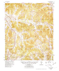
1954 Map of Duck Hill
USGS Topo · Published 1954About this map
The hills of north-central Mississippi meet the valley of the Illinois Central railroad in this mid-century portrait of Montgomery and Grenada Counties. The landscape is defined by its rural community centers, often centered on combined institutions like Spring Hill Sch, Ch & Cem and Hays Creek Ch Sch & Cem, which serve as vital landmarks for genealogists tracing family histories. The presence of Camp McCain (Abandoned) in the northwest corner speaks to the area's military history during the previous decade, while an underground cable and an Strip Mine (Abandoned) indicate the evolving infrastructure and industry of the 1950s.
Find a feature on this map
76 named features on this map. Tap any name to fly to it.
Don’t see what you’re looking for? This feature index may not catch every label — zoom into the map to look around manually.
Map Details
Editions of this 1954 Duck Hill Map
2 editions found
Other maps of this area

1953 · Walthall
USGS Topo · 1:62,500

1953 · West Point
USGS Topo · 1:250,000

1954 · Pittsboro
USGS Topo · 1:62,500

1954 · Grenada
USGS Topo · 1:62,500

1954 · McCarley
USGS Topo · 1:62,500

1955 · Coffeeville
USGS Topo · 1:62,500

1958 · West Point
USGS Topo · 1:250,000

1963 · West Point
USGS Topo · 1:250,000

1966 · Kilmichael
USGS Topo · 1:24,000

1966 · Winona
USGS Topo · 1:24,000