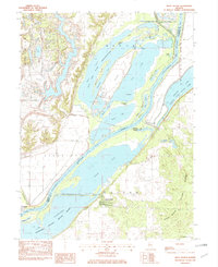
1982 Map of Duck Island
USGS Topo · Published 1982About this map
The Illinois River serves as the primary artery through this riverfront landscape, dividing the riverfront community of Liverpool from the dense wetlands and conservation tracts to the east. By the early 1980s, the region was defined by a massive network of protected lands, including the Chautauqua National Wildlife Refuge and the Rice Lake State Conservation Area. These areas preserve a complex system of backwater lakes and sloughs, such as Miserable Lake and Pond Lily Lake, which speak to the historic hydrological patterns of the Illinois River valley before modern reclamation.
Find a feature on this map
35 named features on this map. Tap any name to fly to it.
Don’t see what you’re looking for? This feature index may not catch every label — zoom into the map to look around manually.
Map Details
Editions of this 1982 Duck Island Map
This is the sole edition of this map. No revisions or reprints were ever made.
Other maps of this area

1912 · Canton
USGS Topo · 1:62,500

1925 · Havana
USGS Topo · 1:62,500

1929 · Manito
USGS Topo · 1:62,500

1930 · Glasford
USGS Topo · 1:62,500

1932 · Manito
USGS Topo · 1:62,500

1947 · St. David
USGS Topo · 1:24,000

1947 · Havana
USGS Topo · 1:24,000

1948 · St. David
USGS Topo · 1:24,000
1948 · Havana
USGS Topo · 1:24,000

1948 · Glasford
USGS Topo · 1:62,500