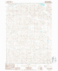
1986 Map of Duck Lake
USGS Topo · Published 1986About this map
Duck Lake sits in the northeast corner of this 1980s landscape, a characteristic water body in the Nebraska Sandhills. The area is defined by the broad reach of Calf Creek Valley, which trends from the west toward the southeast, cutting a distinct path through the surrounding terrain. Small watercourses like Pass Creek drain the northern sections, while the small settlement of Higgins appears in the eastern reaches, near the boundary between Range 29 West and Range 28 West. This map, based on 1983 photography and 1984 field checks, captures the rural character of Cherry County before modern developments, showing the sparse distribution of named places and the dominance of natural drainage patterns in the High Plains.
Find a feature on this map
6 named features on this map. Tap any name to fly to it.
Don’t see what you’re looking for? This feature index may not catch every label — zoom into the map to look around manually.
Map Details
Editions of this 1986 Duck Lake Map
This is the sole edition of this map. No revisions or reprints were ever made.
Other maps of this area

1948 · Seneca
USGS Topo · 1:62,500

1948 · Seneca 4
USGS Topo · 1:62,500

1949 · Seneca 4
USGS Topo · 1:62,500

1951 · Seneca
USGS Topo · 1:62,500

1951 · Bull Lake
USGS Topo · 1:62,500

1951 · Brownlee
USGS Topo · 1:62,500

1957 · Valentine
USGS Topo · 1:250,000

1959 · Valentine
USGS Topo · 1:250,000

1985 · Goose Creek
USGS Topo · 1:100,000
1985 · Brownlee
USGS Topo · 1:24,000