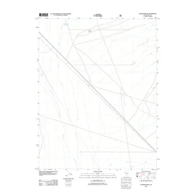
2012 Map of Duckwater SE
USGS Topo · Published 2012About this map
Bull Creek Reservoir sits in the northern reaches of this high-desert landscape, serving as a primary point of water management in a region defined by seasonal drainages. The area is characterized by the convergence of several intermittent watercourses, including Bull Cr, Duckwater Cr, and Kern Cr, which flow through the arid basins of Nye County. These water patterns dictate the movement across the terrain, with Broom Canyon providing a natural corridor through the surrounding elevation. State Route 379 cuts a straight path diagonally across the quadrangle, representing the primary infrastructure connecting these remote basins. The presence of isolated water sources like Blue Spring and Box Spring highlights the critical points of hydration that have historically supported ranching and transit in the Great Basin.
Find a feature on this map
9 named features on this map. Tap any name to fly to it.
Don’t see what you’re looking for? This feature index may not catch every label — zoom into the map to look around manually.
Map Details
Editions of this 2012 Duckwater SE Map
This is the sole edition of this map. No revisions or reprints were ever made.
Other maps of this area

1956 · Lund
USGS Topo · 1:250,000

1957 · Currant Mtn
USGS Topo · 1:62,500

1960 · Lund
USGS Topo · 1:250,000

1964 · Blue Eagle Springs
USGS Topo · 1:62,500

1964 · Duckwater
USGS Topo · 1:62,500

1964 · Currant
USGS Topo · 1:62,500

1964 · Currant Mtn
USGS Topo · 1:62,500

1980 · Duckwater
USGS Topo · 1:100,000
1990 · Bradshaw Spring
USGS Topo · 1:24,000
1990 · Duckwater NE
USGS Topo · 1:24,000