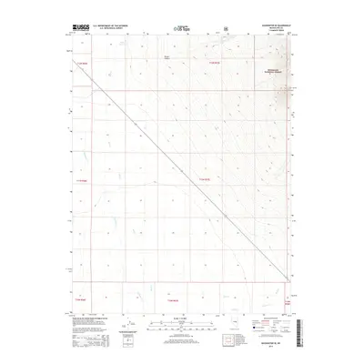
2014 Map of Duckwater SE
USGS Topo · Published 2014About this map
The high desert drainage of Duckwater Cr and its tributaries define this 2014 survey of central Nevada's high basins. The landscape is dominated by the western reaches of the Humboldt National Forest, where steep terrain falls away toward the flats. Water is the primary marker of human activity and survival in this arid region, as evidenced by the engineering of the Bull Cr Reservoir and the reliance on scattered sources like Blue Spring and Box Spring. A solitary paved route, 379, cuts a diagonal line across the grid of township and range lines, connecting the northern canyons such as Broom Canyon to the southern valley floor near Currant Cr. This map captures a classic Great Basin environment where the presence of water determines the locations of landmarks like Kern Cr and Bull Cr.
Find a feature on this map
17 named features on this map. Tap any name to fly to it.
Don’t see what you’re looking for? This feature index may not catch every label — zoom into the map to look around manually.
Map Details
Editions of this 2014 Duckwater SE Map
This is the sole edition of this map. No revisions or reprints were ever made.
Other maps of this area

1956 · Lund
USGS Topo · 1:250,000

1957 · Currant Mtn
USGS Topo · 1:62,500

1960 · Lund
USGS Topo · 1:250,000

1964 · Blue Eagle Springs
USGS Topo · 1:62,500

1964 · Duckwater
USGS Topo · 1:62,500

1964 · Currant
USGS Topo · 1:62,500

1964 · Currant Mtn
USGS Topo · 1:62,500

1980 · Duckwater
USGS Topo · 1:100,000
1990 · Bradshaw Spring
USGS Topo · 1:24,000
1990 · Duckwater NE
USGS Topo · 1:24,000