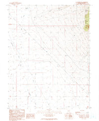
1990 Map of Duckwater SE
USGS Topo · Published 1990About this map
The Humboldt National Forest marks the eastern boundary of this arid basin, where seasonal drainages flow toward the valley floor. Water management is the primary human footprint in this corner of Nye County, evidenced by features such as Bull Creek Reservoir, a Water Tank, and Box Spring located near the forest edge. The landscape is defined by the convergence of Bull Creek and Duckwater Creek as they move south through the township. While primarily open range, the presence of several Drill Hole sites and a Gravel Pit along the 4WD tracks suggests periodic resource exploration and maintenance. These scattered markers and the network of primitive roads reveal the sparse, utilitarian nature of the high desert interior during the late twentieth century.
Find a feature on this map
19 named features on this map. Tap any name to fly to it.
Don’t see what you’re looking for? This feature index may not catch every label — zoom into the map to look around manually.
Map Details
Editions of this 1990 Duckwater SE Map
This is the sole edition of this map. No revisions or reprints were ever made.
Other maps of this area

1956 · Lund
USGS Topo · 1:250,000

1957 · Currant Mtn
USGS Topo · 1:62,500

1960 · Lund
USGS Topo · 1:250,000

1964 · Blue Eagle Springs
USGS Topo · 1:62,500

1964 · Duckwater
USGS Topo · 1:62,500

1964 · Currant
USGS Topo · 1:62,500

1964 · Currant Mtn
USGS Topo · 1:62,500

1980 · Duckwater
USGS Topo · 1:100,000
1990 · Bradshaw Spring
USGS Topo · 1:24,000
1990 · Duckwater NE
USGS Topo · 1:24,000