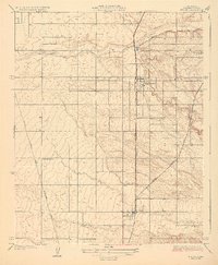
1929 Map of Ducor
USGS Topo · Published 1929About this map
Terra Bella and Ducor anchor this agricultural landscape during the late 1920s, a period defined by the expanding infrastructure of California's Central Valley. The map captures the sophisticated rail and transit networks necessary for moving the region's produce, featuring the Southern Pacific, the Atchison Topeka and Santa Fe, and the Orange Belt lines. These tracks run parallel to the Pacific Highway, illustrating the transition of transportation dominance from rail to road.
Find a feature on this map
11 named features on this map. Tap any name to fly to it.
Don’t see what you’re looking for? This feature index may not catch every label — zoom into the map to look around manually.
Map Details
Editions of this 1929 Ducor Map
3 editions found
Other maps of this area

1904 · Kaweah
USGS Topo · 1:125,000

1909 · Kaweah
USGS Topo · 1:125,000

1926 · Quincy School
USGS Topo · 1:31,680

1928 · Woodville
USGS Topo · 1:31,680

1929 · Delano
USGS Topo · 1:31,680

1929 · Sausalito School
USGS Topo · 1:31,680

1929 · Richgrove
USGS Topo · 1:31,680

1929 · Porterville
USGS Topo · 1:31,680

1929 · Quincy School
USGS Topo · 1:31,680

1929 · Ducor
USGS Topo · 1:31,680