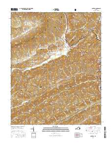
2016 Map of Duffield
USGS Topo · Published 2016About this map
Duffield serves as a central hub in this corner of Scott County, where the N Fork Clinch River and the Clinchfield RR navigate the complex topography of the Appalachian ridges. The map reveals a high density of family burial grounds, such as the Speer-Gilliam-Sloan Cem and Wills Campbells Cem, reflecting a long history of kin-based settlement across Speers Valley and Purchase Valley. Large tracts of the Jefferson National Forest dominate the northern terrain, while the steep slopes of Purchase Ridge and Copper Ridge define the drainage patterns of Watts Br and Stock Cr. This survey provides a precise record of rural community centers like Pattonsville and Sloantown during a period of modern road development, including Natural Tunnel Pkwy and Purchase Ridge Rd, which connect these historically isolated hollows.
Find a feature on this map
109 named features on this map. Tap any name to fly to it.
Don’t see what you’re looking for? This feature index may not catch every label — zoom into the map to look around manually.
Map Details
Editions of this 2016 Duffield Map
This is the sole edition of this map. No revisions or reprints were ever made.
Other maps of this area

1894 · Estillville
USGS Topo · 1:125,000

1920 · Wise
USGS Topo · 1:48,000

1921 · Big Stone Gap
USGS Topo · 1:48,000

1921 · Wise
USGS Topo · 1:62,500

1922 · Big Stone Gap
USGS Topo · 1:62,500

1929 · Big Stone Gap
USGS Topo · 1:62,500

1935 · Moggasin
USGS Topo · 1:48,000

1935 · Looneys Gap
USGS Topo · 1:24,000

1935 · East Stone Gap
USGS Topo · 1:24,000
1935 · Keokee
USGS Topo · 1:24,000