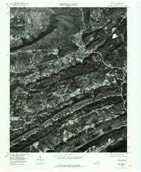
1976 Map of Duffield
USGS Topo · Published 1981About this map
North Fork Clinch River winds through the ridge-and-valley landscape of Scott County, providing a natural corridor for the transportation routes that define this Appalachian region. This orthophotoquad reveals the concentrated settlement patterns of the mid-1970s, where small communities like Duffield and Fraleytown occupy the limited flat ground between steep wooded slopes. The imagery captures the meeting of the North Fork and the main Clinch River near Clinchport, highlighting how the river system dictated the placement of rail lines and roadways. Further west, the map shows the more dispersed homesteads of Pattonsville and the agricultural clearings along Wallen Creek. South of the primary valley, Drakes Gap serves as a critical passage through the ridges, connecting the area near Sloantown to the northern settlements. This aerial perspective offers researchers a clear view of land use before more modern development, marking the balance between industrial sites like Sunbright and the surrounding wilderness.
Find a feature on this map
11 named features on this map. Tap any name to fly to it.
Don’t see what you’re looking for? This feature index may not catch every label — zoom into the map to look around manually.
Map Details
Editions of this 1976 Duffield Map
This is the sole edition of this map. No revisions or reprints were ever made.
Other maps of this area

1894 · Estillville
USGS Topo · 1:125,000

1920 · Wise
USGS Topo · 1:48,000

1921 · Big Stone Gap
USGS Topo · 1:48,000

1921 · Wise
USGS Topo · 1:62,500

1922 · Big Stone Gap
USGS Topo · 1:62,500

1929 · Big Stone Gap
USGS Topo · 1:62,500

1935 · Moggasin
USGS Topo · 1:48,000

1935 · Looneys Gap
USGS Topo · 1:24,000

1935 · East Stone Gap
USGS Topo · 1:24,000
1935 · Keokee
USGS Topo · 1:24,000