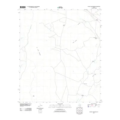
2010 Map of Dugout Mountain
USGS Topo · Published 2010About this map
Old Payne Ranch and the small settlement of Lenox anchor this Brewster County landscape, where the high desert terrain is shaped by the Del Norte Mountains and the Payne Hills. The mapping reveals a ranching economy reliant on scattered water sources and infrastructure, with several named landmarks such as the Red Windmill, Billy Trap Windmill, and Cedar Windmill serving as vital navigational points across the arid expanse.
Find a feature on this map
15 named features on this map. Tap any name to fly to it.
Don’t see what you’re looking for? This feature index may not catch every label — zoom into the map to look around manually.
Map Details
Editions of this 2010 Dugout Mountain Map
This is the sole edition of this map. No revisions or reprints were ever made.
Other maps of this area

1895 · Alpine
USGS Topo · 1:125,000

1920 · Monument Spring
USGS Topo · 1:62,500

1921 · Monument Spring
USGS Topo · 1:62,500

1923 · Altuda
USGS Topo · 1:62,500

1954 · Fort Stockton
USGS Topo · 1:250,000

1958 · Fort Stockton
USGS Topo · 1:250,000

1972 · Bird Mountain
USGS Topo · 1:24,000

1973 · Fort Stockton
USGS Topo · 1:250,000
1983 · Mount Ord
USGS Topo · 1:24,000
1983 · Elephant Mountain
USGS Topo · 1:24,000