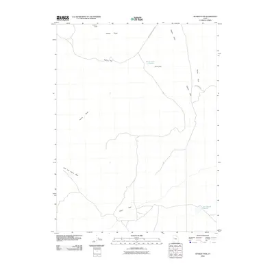
2010 Map of Dugway Pass
USGS Topo · Published 2010About this map
Pyramid Peak stands as a prominent landmark in the north, anchoring a landscape defined by the meeting of the Dugway Range and the Thomas Range. This 2010 survey of the Juab County desert illustrates the sparse but critical water management infrastructure necessary for this environment, featuring the Bittner Knoll Reservoir and East Topaz 2 Reservoir. Movement through the region is dictated by the passage through Dugway Pass and along the established routes of the Simpson Springs Callao Rd and Flint Springs Rd. The map provides a clear record of the drainage patterns through the Dugway Valley, dominated by the meandering path of Pismire Wash. This data reflects the modern geodetic standards used by the U.S. Geological Survey to document the arid interior of the Great Basin.
Find a feature on this map
11 named features on this map. Tap any name to fly to it.
Don’t see what you’re looking for? This feature index may not catch every label — zoom into the map to look around manually.
Map Details
Editions of this 2010 Dugway Pass Map
This is the sole edition of this map. No revisions or reprints were ever made.
Other maps of this area

1885 · Sevier Desert
USGS Topo · 1:250,000

1908 · Fish Springs
USGS Topo · 1:250,000

1910 · Fish Springs
USGS Topo · 1:250,000

1953 · Dugway Range NE
USGS Topo · 1:24,000

1953 · Dugway Pass
USGS Topo · 1:24,000

1953 · Dugway Range
USGS Topo · 1:62,500

1953 · Topaz Mtn
USGS Topo · 1:62,500

1953 · Dugway Range NW
USGS Topo · 1:24,000

1953 · Delta
USGS Topo · 1:250,000
1955 · Table Mountain
USGS Topo · 1:24,000