
1953 Map of Dugway Range NW
USGS Topo · Published 1955About this map
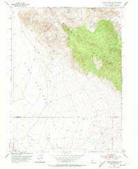
High-altitude desert terrain and mining activity define this western Utah landscape, surveyed in the early 1950s. The topography is dominated by the Dugway Range and the expansive basin of Fish Springs Flat to the west. Industrial exploration is evident throughout the mountain peaks, where the Rainbow Mines, Four Metal Mine, and Cannon Mine are located alongside various unnamed shafts and prospects. This area marks a clear boundary between Tooele Co and Juab Co, illustrating a remote section of the Great Basin where mineral extraction was the primary human imprint. Water resources appear scarce in this environment, indicated by the singular Well No 28 positioned on the flat, highlighting the logistical challenges faced by early mid-century mining operations in the region.
Find a feature on this map
11 named features on this map. Tap any name to fly to it.
Don’t see what you’re looking for? This feature index may not catch every label — zoom into the map to look around manually.
Map Details
Editions of this 1953 Dugway Range NW Map
2 editions found
Other maps of this area

1908 · Fish Springs
USGS Topo · 1:250,000

1910 · Fish Springs
USGS Topo · 1:250,000

1953 · Dugway Range NE
USGS Topo · 1:24,000

1953 · Dugway Pass
USGS Topo · 1:24,000

1953 · Dugway Range
USGS Topo · 1:62,500

1953 · Tooele
USGS Topo · 1:250,000

1953 · Delta
USGS Topo · 1:250,000

1954 · Dugway Proving Ground SE
USGS Topo · 1:24,000

1954 · Dugway Proving Ground SW
USGS Topo · 1:24,000

1954 · Granite Peak SE
USGS Topo · 1:24,000