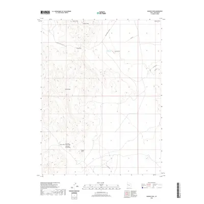
2020 Map of Dugway Pass
USGS Topo · Published 2020About this map
Dugway Pass serves as a critical geographic notch through the high terrain of the Dugway Range in this section of the Great Basin. To the north, Pyramid Peak overlooks the arid expanse of the Dugway Valley, while the southern reaches of the map are defined by the northern edges of the Thomas Range. Human influence in this remote landscape is evidenced by the high-desert road network, including the Simpson Springs-Callao Rd, which provides passage through the gap. Water features are sparse but notable, with the Bittner Knoll Reservoir situated near Bittner Knoll. Further south, the drainage patterns are dominated by the North Fork Pismire Wash and South Fork Pismire Wash, which cut through the area near the Pismire Knolls, illustrating the stark hydrology typical of the Juab County wilderness.
Find a feature on this map
15 named features on this map. Tap any name to fly to it.
Don’t see what you’re looking for? This feature index may not catch every label — zoom into the map to look around manually.
Map Details
Editions of this 2020 Dugway Pass Map
This is the sole edition of this map. No revisions or reprints were ever made.
Other maps of this area

1885 · Sevier Desert
USGS Topo · 1:250,000

1908 · Fish Springs
USGS Topo · 1:250,000

1910 · Fish Springs
USGS Topo · 1:250,000

1953 · Dugway Range NE
USGS Topo · 1:24,000

1953 · Dugway Pass
USGS Topo · 1:24,000

1953 · Dugway Range
USGS Topo · 1:62,500

1953 · Topaz Mtn
USGS Topo · 1:62,500

1953 · Dugway Range NW
USGS Topo · 1:24,000

1953 · Delta
USGS Topo · 1:250,000
1955 · Table Mountain
USGS Topo · 1:24,000