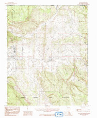
1983 Map of Dulce
USGS Topo · Published 1992About this map
The Jicarilla Apache Indian Reservation encompasses this high-altitude landscape along the New Mexico and Colorado state line, where the high desert meets the southern Rockies. Central to the region is Dulce, the tribal headquarters, situated near the headwaters of Dulce Creek. The map records the path of the Old RR Grade, which follows the contours of the terrain through Amargo and Lumberton, tracing the legacy of narrow-gauge rail transportation that once connected these remote settlements. The rugged topography is defined by significant elevations like Dulce Mountain and Archuleta Mesa, while the Navajo River cuts through the northern sector. Small outposts such as Webb and infrastructure like the Dulce Airport highlight the sparse but vital network of habitation in this mountainous borderland during the early 1980s.
Find a feature on this map
24 named features on this map. Tap any name to fly to it.
Don’t see what you’re looking for? This feature index may not catch every label — zoom into the map to look around manually.
Map Details
Editions of this 1983 Dulce Map
2 editions found
Other maps of this area

1889 · Largo
USGS Topo · 1:250,000

1895 · Largo
USGS Topo · 1:250,000

1913 · Summitville
USGS Topo · 1:125,000

1915 · Summitville
USGS Topo · 1:125,000

1924 · Pagosa Springs
USGS Topo · 1:125,000

1927 · Pagosa Springs
USGS Topo · 1:125,000

1945 · Durango
USGS Topo · 1:250,000

1953 · Durango
USGS Topo · 1:250,000

1954 · Durango
USGS Topo · 1:250,000

1954 · Aztec
USGS Topo · 1:250,000