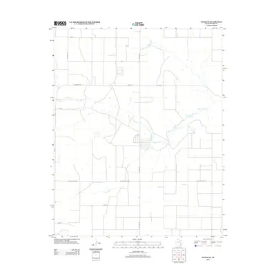
2012 Map of Dumas NE
USGS Topo · Published 2012About this map
S Palo Duro Cr snakes through the high plains of Moore County, carving a subtle drainage pattern across this cattle-and-energy landscape. In 2012, the region reflects a modern agricultural and industrial network, where traditional ranching territory is divided by a grid of specialized transport routes. The naming of Texas Beef Rd and Morton Elevator Rd points directly to the area's primary economic drivers—commercial livestock operations and grain storage. Further infrastructure, such as Light Plant Rd and Maxus Rd, hints at the utilities and petroleum interests that power the Panhandle. Near the eastern edge, the Griffin Estate Lake Number 1 represents one of the few managed water features in an otherwise arid expanse defined by ranching corridors like Ranch Road 119.
Find a feature on this map
14 named features on this map. Tap any name to fly to it.
Don’t see what you’re looking for? This feature index may not catch every label — zoom into the map to look around manually.
Map Details
Editions of this 2012 Dumas NE Map
This is the sole edition of this map. No revisions or reprints were ever made.
Other maps of this area

1954 · Perryton
USGS Topo · 1:250,000

1954 · Amarillo
USGS Topo · 1:250,000

1958 · Perryton
USGS Topo · 1:250,000

1958 · Amarillo
USGS Topo · 1:250,000

1963 · Cactus East
USGS Topo · 1:24,000

1965 · Dumas South
USGS Topo · 1:24,000
1965 · Dumas North
USGS Topo · 1:24,000
1972 · Little Blue Creek
USGS Topo · 1:24,000

1972 · Dumas NE
USGS Topo · 1:24,000
1972 · Pollard Creek
USGS Topo · 1:24,000