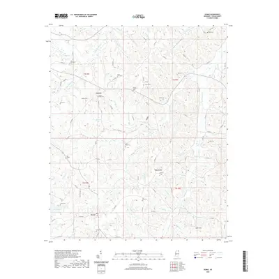
2020 Map of Dumas
USGS Topo · Published 2020About this map
Dumas and the surrounding Tippah County uplands are defined by a complex network of creeks feeding into the Hatchie River and Little Hatchie River. The landscape is scattered with small settlements and numerous cemeteries that reflect the area's deep-rooted rural community life. Significant burial grounds such as Mount Olive Cem, Westminster Cem, and Paynes Chapel Cem are tucked among the hills, often near minor tributaries like Jennings Br and Mitchell Br.
Find a feature on this map
107 named features on this map. Tap any name to fly to it.
Don’t see what you’re looking for? This feature index may not catch every label — zoom into the map to look around manually.
Map Details
Editions of this 2020 Dumas Map
This is the sole edition of this map. No revisions or reprints were ever made.
Other maps of this area

1921 · Booneville
USGS Topo · 1:48,000

1922 · Booneville
USGS Topo · 1:62,500

1950 · Corinth
USGS Topo · 1:62,500

1951 · Walnut
USGS Topo · 1:62,500

1955 · Ripley
USGS Topo · 1:62,500

1956 · Tupelo
USGS Topo · 1:250,000

1958 · Tupelo
USGS Topo · 1:250,000

1972 · Jumpertown
USGS Topo · 1:24,000
1973 · Baldwyn
USGS Topo · 1:24,000
1982 · Kossuth South
USGS Topo · 1:24,000