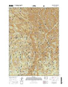
2017 Map of Dumont Creek
USGS Topo · Published 2017About this map
The South Umpqua River and its network of mountain tributaries dominate this corner of the Umpqua National Forest. The landscape is defined by the steep elevation changes between high points like Clayton Point and Hob Knob and the deep drainage basins of Dumont Creek and Boulder Creek. This 2017 survey documents an extensive system of National Forest Development Roads, such as Nat For Dev Rd 800 and Nat For Dev Rd 300, which provide access to timber resources and high ridges including Smith Ridge. The density of these service roads indicates the intensive management of these Douglas County timberlands, while specialized routes like Smith Ridge Rd and the Sam Cr Loop trail suggest a geography utilized for both industry and backcountry recreation. Named features like Boulder Rock and various creek confluences along the river provide fixed reference points for local navigation within the dense forest canopy.
Find a feature on this map
60 named features on this map. Tap any name to fly to it.
Don’t see what you’re looking for? This feature index may not catch every label — zoom into the map to look around manually.
Map Details
Editions of this 2017 Dumont Creek Map
This is the sole edition of this map. No revisions or reprints were ever made.
Other maps of this area

1891 · Ashland
USGS Topo · 1:250,000

1893 · Ashland
USGS Topo · 1:250,000

1897 · Ashland
USGS Topo · 1:250,000

1944 · Tiller
USGS Topo · 1:62,500

1944 · Abbott Butte
USGS Topo · 1:62,500

1947 · Abbott Butte
USGS Topo · 1:62,500

1955 · Quartz Mtn
USGS Topo · 1:62,500

1955 · Red Butte
USGS Topo · 1:62,500

1955 · Medford
USGS Topo · 1:250,000

1957 · Medford
USGS Topo · 1:250,000