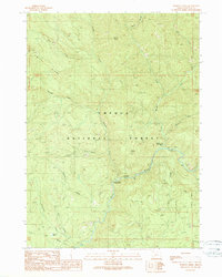
1989 Map of Dumont Creek
USGS Topo · Published 1990About this map
Umpqua National Forest defines the character of this Douglas County landscape, where the South Fork Umpqua River carves through a complex network of drainages. The area is heavily marked by industrial forestry and resource extraction, evidenced by numerous quarries and borrow pits scattered across the ridges. Early recreation sites are established at the Boulder Creek Campground and Dumont Creek Campground, providing access to the deep interior of the Cascades. Notable topographical landmarks like Smith Ridge, Boulder Rock, and Clayton Point overlook a system of watercourses including Dumont Creek, Budd Creek, and the isolated Shadow Pond. The eastern boundary is defined by the Willamette Meridian, a critical surveying line for Oregon land claims, while names like Adit Creek hint at the area's prospector history and mineral exploration.
Find a feature on this map
27 named features on this map. Tap any name to fly to it.
Don’t see what you’re looking for? This feature index may not catch every label — zoom into the map to look around manually.
Map Details
Editions of this 1989 Dumont Creek Map
This is the sole edition of this map. No revisions or reprints were ever made.
Other maps of this area

1891 · Ashland
USGS Topo · 1:250,000

1893 · Ashland
USGS Topo · 1:250,000

1897 · Ashland
USGS Topo · 1:250,000

1944 · Tiller
USGS Topo · 1:62,500

1944 · Abbott Butte
USGS Topo · 1:62,500

1947 · Abbott Butte
USGS Topo · 1:62,500

1955 · Quartz Mtn
USGS Topo · 1:62,500

1955 · Red Butte
USGS Topo · 1:62,500

1955 · Medford
USGS Topo · 1:250,000

1957 · Medford
USGS Topo · 1:250,000