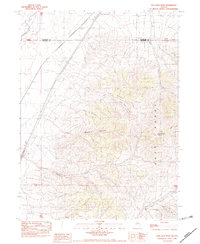
1982 Map of Dun Glen Peak
USGS Topo · Published 1982About this map
Dun Glen Peak dominates the northern reaches of the East Range, a landscape defined by sharp elevation changes and deeply etched drainage systems. This early 1980s provisional survey highlights the mining and utility infrastructure integrated into the high desert terrain. The presence of the Auld Lang Syne Mine and its namesake Auld Lang Syne Gulch in the southern portion of the sheet points to a legacy of mineral extraction, while a series of modern wood-pole power lines cut across the western flats. Natural water sources like Big Alkali Spring and seasonal drainages including Raspberry Creek and Rose Creek carve through the prominent canyons, such as Cosgrave Canyon and White Horse Canyon, providing the primary topographical relief in an area primarily utilized for industrial access and resource management.
Find a feature on this map
19 named features on this map. Tap any name to fly to it.
Don’t see what you’re looking for? This feature index may not catch every label — zoom into the map to look around manually.
Map Details
Editions of this 1982 Dun Glen Peak Map
This is the sole edition of this map. No revisions or reprints were ever made.
Other maps of this area

1931 · Lovelock
USGS Topo · 1:250,000

1932 · Sonoma Range
USGS Topo · 1:250,000

1935 · Lovelock
USGS Topo · 1:250,000

1939 · Sonoma Range
USGS Topo · 1:250,000

1939 · Eugene Mountains Area
USGS Topo · 1:62,500

1942 · Eugene Mountains Area
USGS Topo · 1:62,500

1955 · Lovelock
USGS Topo · 1:250,000

1955 · Winnemucca
USGS Topo · 1:250,000

1956 · Imlay
USGS Topo · 1:62,500

1958 · Winnemucca
USGS Topo · 1:250,000