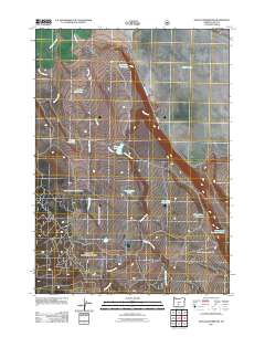
2011 Map of Duncan Reservoir
USGS Topo · Published 2011About this map
Silver Lake dominates the northeastern landscape in this 2011 survey of Lake County, Oregon, where the arid high-desert environment is defined by its intermittent water sources. The map reveals an intricate network of drainage and catchment systems essential for land management, including Duncan Reservoir and several strategically placed waterholes. Named landmarks like O'Keefe Waterhole, Dudley Waterhole, and Two Sheep Waterhole suggest a history of livestock grazing and the critical importance of localized water access in this region.
Find a feature on this map
17 named features on this map. Tap any name to fly to it.
Don’t see what you’re looking for? This feature index may not catch every label — zoom into the map to look around manually.
Map Details
Editions of this 2011 Duncan Reservoir Map
This is the sole edition of this map. No revisions or reprints were ever made.
Other maps of this area

1889 · Klamath
USGS Topo · 1:250,000

1894 · Klamath
USGS Topo · 1:250,000

1955 · Crescent
USGS Topo · 1:250,000

1955 · Klamath Falls
USGS Topo · 1:250,000

1957 · Crescent
USGS Topo · 1:250,000

1958 · Crescent
USGS Topo · 1:250,000

1958 · Klamath Falls
USGS Topo · 1:250,000

1960 · Sycan Marsh
USGS Topo · 1:62,500

1966 · Summer Lake
USGS Topo · 1:24,000

1966 · Foster Butte
USGS Topo · 1:24,000