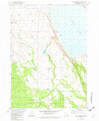
1982 Map of Duncan Reservoir
USGS Topo · Published 1982About this map
Silver Lake dominates the northeastern corner of this high-desert landscape, where the waters edge against the steep terrain of Dead Indian Rim. The map documents a sparsely populated region of Lake County defined by livestock and water management, evidenced by the presence of the Murphy Windmill and several isolated wells such as Well 4348 and Well 4356.
Find a feature on this map
25 named features on this map. Tap any name to fly to it.
Don’t see what you’re looking for? This feature index may not catch every label — zoom into the map to look around manually.
Map Details
Editions of this 1982 Duncan Reservoir Map
This is the sole edition of this map. No revisions or reprints were ever made.
Other maps of this area

1889 · Klamath
USGS Topo · 1:250,000

1894 · Klamath
USGS Topo · 1:250,000

1955 · Crescent
USGS Topo · 1:250,000

1955 · Klamath Falls
USGS Topo · 1:250,000

1957 · Crescent
USGS Topo · 1:250,000

1958 · Crescent
USGS Topo · 1:250,000

1958 · Klamath Falls
USGS Topo · 1:250,000

1960 · Sycan Marsh
USGS Topo · 1:62,500

1966 · Summer Lake
USGS Topo · 1:24,000

1966 · Foster Butte
USGS Topo · 1:24,000