
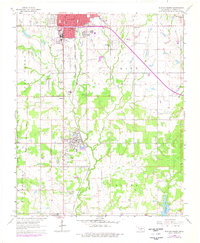
1964 Map of Duncan South
USGS Topo · Published 1965About this map
The Indian Territory Line and Old Oklahoma Boundary Line bisect this 1964 survey of southern Stephens County, marking a historic transition in the landscape north of Comanche. The industrial character of the era is evident in the extensive oil wells and the Halliburton Field, which sprawl across the terrain alongside the Chicago Rock Island and Pacific railroad corridor. The city of Duncan serves as the primary hub, with its urban footprint extending past Duncan Park and the Fairground.
Find a feature on this map
36 named features on this map. Tap any name to fly to it.
Don’t see what you’re looking for? This feature index may not catch every label — zoom into the map to look around manually.
Map Details
Editions of this 1964 Duncan South Map
2 editions found
Other maps of this area

1901 · Addington
USGS Topo · 1:125,000

1902 · Rush Springs
USGS Topo · 1:125,000

1949 · Nellie
USGS Topo · 1:62,500

1950 · Marlow
USGS Topo · 1:62,500

1951 · Marlow
USGS Topo · 1:62,500

1955 · Lawton
USGS Topo · 1:250,000

1956 · Nellie
USGS Topo · 1:24,000

1956 · Nellie
USGS Topo · 1:62,500

1957 · Ardmore
USGS Topo · 1:250,000

1962 · Temple
USGS Topo · 1:62,500