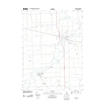
2011 Map of Dundee
USGS Topo · Published 2011About this map
The River Raisin meanders across this landscape of Monroe County, defining the growth of local settlements from Dundee in the northeast to Petersburg in the southwest. A dense network of agricultural drains, including Stacy Drain and Wittkop Drain, segments the surrounding fields, illustrating the managed water system required for this corner of Michigan. Smaller hamlets like Rea and Diann are situated along rail corridors, while Petersburg Junction marks a specific point of historical rail infrastructure south of the main town. Genealogists will find several notable burial grounds, such as the Petersburg Village Cemetery and Barber Cemetery, providing clear physical links to the area's early residents. The presence of the Dundee Post Office and local landmarks like Lada Airport highlight the mix of traditional village centers and modern rural transit.
Find a feature on this map
30 named features on this map. Tap any name to fly to it.
Don’t see what you’re looking for? This feature index may not catch every label — zoom into the map to look around manually.
Map Details
Editions of this 2011 Dundee Map
This is the sole edition of this map. No revisions or reprints were ever made.
Other maps of this area

1902 · Ypsilanti
USGS Topo · 1:62,500

1904 · Ann Arbor
USGS Topo · 1:125,000

1906 · Ypsilanti
USGS Topo · 1:62,500

1906 · Saline
USGS Topo · 1:62,500

1908 · Ann Arbor
USGS Topo · 1:125,000

1912 · Dundee
USGS Topo · 1:62,500

1926 · Dundee
USGS Topo · 1:62,500

1936 · Samaria
USGS Topo · 1:31,680
1936 · Maybee
USGS Topo · 1:31,680
1936 · Ida
USGS Topo · 1:31,680