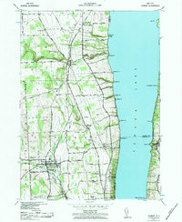
1942 Map of Dundee
USGS Topo · Published 1984About this map
Seneca Lake dominates the eastern half of this landscape, its steep western shore carved by numerous drainages like Indian Run and Plum Creek. During this wartime era, the region maintained a strong agrarian and institutional character, anchored by the village of Dundee and the notable Lakemont Academy further east. The map captures a vital transportation corridor where the Pennsylvania RR and New York Central RR run nearly parallel through Himrod, reflecting the importance of rail transit for both freight and passengers in the Finger Lakes region. Rural life is well-documented through numerous district schoolhouses, including School No 12 and School No 5, alongside several established burying grounds such as Hillside Cem and Grove Mount Cem. Small settlements like Starkey and Randall Crossing serve as points of interest for those tracing family roots in Yates and Seneca counties.
Find a feature on this map
60 named features on this map. Tap any name to fly to it.
Don’t see what you’re looking for? This feature index may not catch every label — zoom into the map to look around manually.
Map Details
Editions of this 1942 Dundee Map
3 editions found
Other maps of this area

1898 · Watkins Glen
USGS Topo · 1:62,500

1901 · Watkins
USGS Topo · 1:62,500

1902 · Ovid
USGS Topo · 1:62,500

1903 · Penn Yan
USGS Topo · 1:62,500

1903 · Hammondsport
USGS Topo · 1:62,500

1905 · Watkins Glen
USGS Topo · 1:125,000

1942 · Penn Yan
USGS Topo · 1:31,680

1942 · Ovid
USGS Topo · 1:31,680

1942 · Dundee
USGS Topo · 1:24,000

1942 · Lodi
USGS Topo · 1:24,000