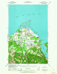
1938 Map of Dungeness
USGS Topo · Published 1964About this map
Dungeness Spit extends into the Strait of Juan de Fuca, sheltering Dungeness Bay and the landmark Dungeness L. H. at its tip. This coastal landscape in Clallam County is defined by a mix of maritime navigation and late 1930s agriculture, where the Chicago Milwaukee St Paul and Pacific railroad cuts through the settlements of Carlsborg and Sequim. The map reveals a high density of rural schoolhouses and family-named landholdings, such as the McNair Ranch and Iver Olsen Ranch, scattered across the plains and foothills.
Find a feature on this map
48 named features on this map. Tap any name to fly to it.
Don’t see what you’re looking for? This feature index may not catch every label — zoom into the map to look around manually.
Map Details
Editions of this 1938 Dungeness Map
2 editions found
Other maps of this area

1918 · Port Angeles
USGS Topo · 1:62,500

1938 · Mt Constance
USGS Topo · 1:125,000

1938 · Dungeness
USGS Topo · 1:62,500

1939 · Port Townsend
USGS Topo · 1:62,500

1939 · Dungeness
USGS Topo · 1:62,500

1940 · Quilcene
USGS Topo · 1:62,500

1941 · Port Angeles
USGS Topo · 1:62,500

1943 · Richardson
USGS Topo · 1:62,500

1944 · Mt. Angeles
USGS Topo · 1:62,500

1946 · Mt. Angeles
USGS Topo · 1:62,500