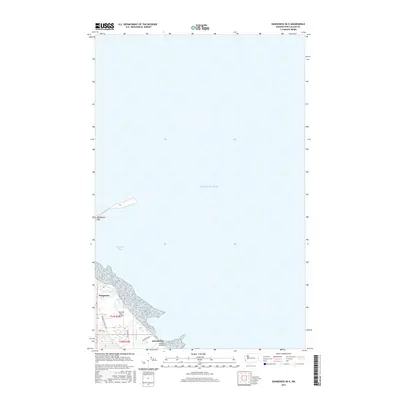
2017 Map of Dungeness OE E
USGS Topo · Published 2017About this map
Dungeness Spit creates a sheltered environment for Dungeness Bay as it reaches into the waters of Puget Sound. This coastal landscape in Clallam County is defined by the intersection of maritime features and local transportation routes like Sequim-Dungeness Way and Jamestown Rd. The settlement of Dungeness serves as a focal point near the coastline, where small-scale aviation is represented by Rucilla's Roost Airport and Flying S Airfield. The geography reflects a mix of low-lying wetlands and drainage such as Cassalery Cr, illustrating the delicate balance of land and sea along the northern edge of the Olympic Peninsula. Local roads like Eberle Ln and Seashore Rd provide access to the rural residential areas and the natural harbor formed by the spit.
Find a feature on this map
13 named features on this map. Tap any name to fly to it.
Don’t see what you’re looking for? This feature index may not catch every label — zoom into the map to look around manually.
Map Details
Editions of this 2017 Dungeness OE E Map
This is the sole edition of this map. No revisions or reprints were ever made.
Other maps of this area

1938 · Dungeness
USGS Topo · 1:62,500

1939 · Port Townsend
USGS Topo · 1:62,500

1939 · Dungeness
USGS Topo · 1:62,500

1943 · Richardson
USGS Topo · 1:62,500
1953 · Gardiner
USGS Topo · 1:24,000

1956 · Sequim
USGS Topo · 1:24,000
1956 · Carlsborg
USGS Topo · 1:24,000

1957 · Richardson
USGS Topo · 1:62,500

1957 · Victoria
USGS Topo · 1:250,000
1975 · Port Townsend
USGS Topo · 1:100,000