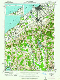
1943 Map of Dunkirk
USGS Topo · Published 1962About this map
The industrial and maritime activity of Dunkirk and Fredonia anchors this mid-century survey along the shores of Lake Erie. The landscape is defined by a dense network of major railroads, including the New York Central, Pennsylvania, and the Nickel Plate, which facilitated the movement of goods through the region's prominent grape-growing belt. Moving inland from the coast at Van Buren Pt, the terrain rises toward the Cassadaga Lakes, where the spiritualist community of Lily Dale and the neighboring village of Cassadaga are situated. This area reflects a distinct era of inland development, with small rural nodes like Stockton, Sinclairville, and Burnhams connected by a web of creeks such as Canadaway Creek and Cassadaga Creek. The presence of the Pickett Sch and the County Hospital provides essential markers for genealogists and local historians tracing the social infrastructure of Chautauqua County during the 1940s.
Find a feature on this map
59 named features on this map. Tap any name to fly to it.
Don’t see what you’re looking for? This feature index may not catch every label — zoom into the map to look around manually.
Map Details
Editions of this 1943 Dunkirk Map
3 editions found

Other maps of this area

1899 · Westfield
USGS Topo · 1:62,500

1899 · Silver Creek
USGS Topo · 1:62,500

1900 · Dunkirk
USGS Topo · 1:62,500

1900 · Cherry Creek
USGS Topo · 1:62,500

1904 · Chautaqua
USGS Topo · 1:62,500

1905 · Clymer
USGS Topo · 1:62,500

1905 · Jamestown
USGS Topo · 1:62,500

1939 · Clymer
USGS Topo · 1:62,500

1941 · Cherry Creek
USGS Topo · 1:62,500

1941 · Chautauqua
USGS Topo · 1:62,500