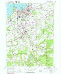
1954 Map of Dunkirk
USGS Topo · Published 1979About this map
Lake Erie defines the northern edge of this Lake Ontario shoreline survey, where Dunkirk and Fredonia form a contiguous corridor of industrial and educational growth. The landscape transition from the busy Dunkirk Harbor, supported by the Conrail and Norfolk and Western rail lines, to the academic grounds of the State University Teachers College illustrates the mid-century expansion of Chautauqua County. Industrial landmarks like the Power Plant and Industrial High Sch stand alongside established institutions such as Union Station and the Armory.
Find a feature on this map
120 named features on this map. Tap any name to fly to it.
Don’t see what you’re looking for? This feature index may not catch every label — zoom into the map to look around manually.
Map Details
Editions of this 1954 Dunkirk Map
3 editions found
Other maps of this area

1899 · Silver Creek
USGS Topo · 1:62,500

1900 · Dunkirk
USGS Topo · 1:62,500

1900 · Cherry Creek
USGS Topo · 1:62,500

1941 · Cherry Creek
USGS Topo · 1:62,500

1943 · Dunkirk
USGS Topo · 1:62,500

1943 · Silver Creek
USGS Topo · 1:24,000

1944 · Silver Creek
USGS Topo · 1:31,680
1954 · Hamlet
USGS Topo · 1:24,000

1954 · Forestville
USGS Topo · 1:24,000
1954 · Dunkirk
USGS Topo · 1:24,000