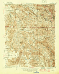
1944 Map of Dunlap
USGS Topo · Published 1944About this map
The Sierra Nevada foothills north of Woodlake appear in this wartime survey, showing the complex boundary between Fresno and Tulare counties. The landscape is defined by a network of ranching operations and isolated mountain settlements, such as Baker Ranch, Auckland Ranch, and Sunny Slope Ranch. Early 20th-century rural infrastructure is well-preserved through the location of local schools, including Squaw Valley Sch and Drum Valley Sch. Moving east into higher elevations, the map records industrial and forestry markers like Neffs Chute and the Badger Fire Sta. Narrow valleys and peaks like Washepie Mtn and Sugarloaf dominate the terrain, which is carved by numerous seasonal drainages such as Sand Creek and Rattlesnake Creek. This edition captures the region's character before modern development, focused on cattle, timber, and the At & SF railroad line cutting through the southwest corner.
Find a feature on this map
75 named features on this map. Tap any name to fly to it.
Don’t see what you’re looking for? This feature index may not catch every label — zoom into the map to look around manually.
Map Details
Editions of this 1944 Dunlap Map
2 editions found

Other maps of this area

1903 · Tehipite
USGS Topo · 1:125,000

1904 · Kaweah
USGS Topo · 1:125,000

1905 · Tehipite
USGS Topo · 1:125,000

1909 · Kaweah
USGS Topo · 1:125,000

1921 · Squaw Valley
USGS Topo · 1:31,680

1921 · Stokes Mountain
USGS Topo · 1:24,000

1922 · Trimmer
USGS Topo · 1:96,000

1923 · Sultana
USGS Topo · 1:31,680

1924 · Citrus Cove
USGS Topo · 1:31,680

1924 · Dinuba
USGS Topo · 1:125,000