
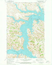
1970 Map of Dunn Center NE
USGS Topo · Published 1973About this map
Lake Sakakawea Elevation 1838 defines the northeastern corner of this 1970s landscape, illustrating a period of controlled water management within the Missouri River Basin. The shoreline is marked by dashed patterns indicating areas subject to controlled inundation, a critical detail for understanding the shifting hydrology of the region during this era. Further inland, the terrain is characterized by the prominent Chimney Butte and the drainage of Chimney Butte Creek, which cuts through the rolling topography toward the lake.
Find a feature on this map
7 named features on this map. Tap any name to fly to it.
Don’t see what you’re looking for? This feature index may not catch every label — zoom into the map to look around manually.
Map Details
Editions of this 1970 Dunn Center NE Map
This is the sole edition of this map. No revisions or reprints were ever made.
Other maps of this area

1953 · Watford City
USGS Topo · 1:250,000

1957 · Watford City
USGS Topo · 1:250,000

1967 · Watford City
USGS Topo · 1:250,000

1970 · Dunn Center NW
USGS Topo · 1:24,000

1970 · Mandaree SW
USGS Topo · 1:24,000

1970 · Halliday NW
USGS Topo · 1:24,000

1970 · Mandaree SE
USGS Topo · 1:24,000
1970 · Saddle Butte SW
USGS Topo · 1:24,000

1973 · Dunn Center
USGS Topo · 1:24,000

1973 · Werner
USGS Topo · 1:24,000