
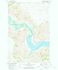
1970 Map of Mandaree SW
USGS Topo · Published 1973About this map
Lake Sakakawea dominates this 1970 landscape, where its waters fill the basin at the confluence with the Little Missouri River. The survey depicts a transition in the Missouri River Basin’s development, showing the massive reservoir’s shoreline as it reaches into the broken badlands of Dunn County. The Fort Berthold Indian Reservation Boundary is clearly delineated, crossing both the open water and the dissected upland terrain. Smaller drainage networks like Moccasin Creek, Dry Creek, and Jim Creek feed into the primary water bodies, illustrating the complex erosion patterns of the region. Aside from a single Pipeline crossing in the northeast, the map shows a landscape largely defined by its natural topography and the engineering of the mid-century river management system.
Find a feature on this map
8 named features on this map. Tap any name to fly to it.
Don’t see what you’re looking for? This feature index may not catch every label — zoom into the map to look around manually.
Map Details
Editions of this 1970 Mandaree SW Map
2 editions found
Other maps of this area

1953 · Watford City
USGS Topo · 1:250,000

1957 · Watford City
USGS Topo · 1:250,000

1967 · Watford City
USGS Topo · 1:250,000

1970 · Mandaree
USGS Topo · 1:24,000

1970 · Lost Bridge
USGS Topo · 1:24,000

1970 · Figure 4 Ranch
USGS Topo · 1:24,000

1970 · Dunn Center NW
USGS Topo · 1:24,000

1970 · Dunn Center NE
USGS Topo · 1:24,000

1970 · Mandaree SE
USGS Topo · 1:24,000
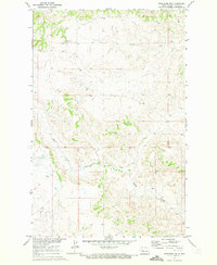
1970 · Mandaree NE
USGS Topo · 1:24,000