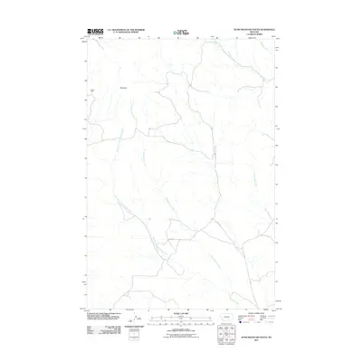
2011 Map of Dunn Mountain South
USGS Topo · Published 2011About this map
Holland Mine and the high point of Red Bluff define the northern reaches of this Yellowstone County landscape. The drainage system is dominated by the sprawling course of Pompeys Pillar Creek and its major tributary, the West Fork Pompeys Pillar Creek, which carve through the terrain as they flow generally southeastward. This 2011 survey reveals a sparsely settled ranching or resource-oriented territory, where local transit relies on a handful of named routes such as Pfister Rd, Sando Rd, and C A Rd. The presence of 06N27E24CDD 01 Spring and various waterways like Railroad Creek and Churn Dash Creek suggest a reliance on these natural water sources in an otherwise arid environment. This map serves as a precise record of the land use and hydrology of the rural Montana interior at the beginning of the decade.
Find a feature on this map
11 named features on this map. Tap any name to fly to it.
Don’t see what you’re looking for? This feature index may not catch every label — zoom into the map to look around manually.
Map Details
Editions of this 2011 Dunn Mountain South Map
This is the sole edition of this map. No revisions or reprints were ever made.
Other maps of this area

1954 · Roundup
USGS Topo · 1:250,000

1958 · Roundup
USGS Topo · 1:250,000

1979 · Roundup
USGS Topo · 1:100,000

1980 · Cherry Spring
USGS Topo · 1:24,000
1980 · North Fork Crooked Creek East
USGS Topo · 1:24,000

1980 · Dunn Mountain South
USGS Topo · 1:24,000
1980 · Cotton Creek
USGS Topo · 1:24,000

1980 · Dunn Mountain North
USGS Topo · 1:24,000

1980 · Signal Mountain
USGS Topo · 1:24,000
1980 · P K Ranch
USGS Topo · 1:24,000