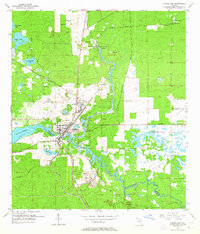
1954 Map of Dunnellon
USGS Topo · Published 1964About this map
The confluence of the Withlacoochee River and Blue Run serves as the focal point for this mid-century look at Marion and Citrus counties. Dunnellon sits at the heart of the sheet, emerging as a rail junction where the Atlantic Coast Line and Seaboard Air Line intersect. The landscape is heavily marked by the region's industrial and natural heritage, featuring numerous Tailings Ponds and an Inactive Mine that point to a history of phosphate or mineral extraction. North of the town center, the crystal-clear waters of Rainbow Springs and Rainbow Falls highlight the unique hydrologic features of the Florida karst landscape, while the presence of the Rockwell Cem and Chatmar provides specific points of interest for genealogists tracking early local families. Further east, the Dunnellon Airport (Abandoned) and Dunnellon Lookout Tower reflect the changing utility of the land during the post-war era.
Find a feature on this map
27 named features on this map. Tap any name to fly to it.
Don’t see what you’re looking for? This feature index may not catch every label — zoom into the map to look around manually.
Map Details
Editions of this 1954 Dunnellon Map
3 editions found
Other maps of this area

1892 · Dunnellon
USGS Topo · 1:62,500

1894 · Dunnellon
USGS Topo · 1:62,500

1895 · Tsala Apopka
USGS Topo · 1:62,500

1954 · Holder
USGS Topo · 1:24,000

1954 · Crystal River
USGS Topo · 1:24,000

1954 · Romeo
USGS Topo · 1:24,000

1954 · Tsala Apopka NE
USGS Topo · 1:24,000

1954 · Dunnellon
USGS Topo · 1:24,000

1954 · Cotton Plant
USGS Topo · 1:24,000

1954 · Dunnellon SE
USGS Topo · 1:24,000