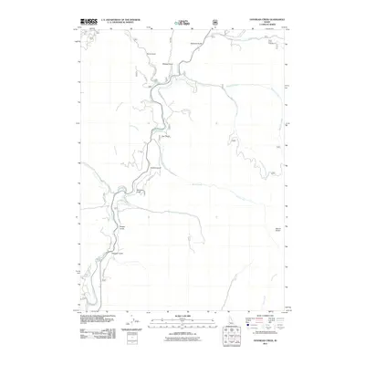
2011 Map of Dunnigan Creek
USGS Topo · Published 2011About this map
Mores Creek serves as the central drainage for this Boise County landscape, carving a winding path that dictates the local road network. The 2011 topography reveals a rugged intersection of canyons and drainages, most notably Dunnigan Creek and Grimes Creek. Residential development and access roads like Mores Creek Rim Rd and Skycrest Way are concentrated in the western reaches, while the eastern portion of the map is dominated by higher elevations, culminating at the summit of Mount Heinen. The names across the landscape—such as Robbers Gulch, Stierman Gulch, and Mudders Gulch—reflect a lineage of early settlers and perhaps a nod to the area's colorful history. Near the northern boundary, the Thorn Creek Campground marks a point of transition between the lower creek valleys and the rising peaks of the Boise National Forest area.
Find a feature on this map
34 named features on this map. Tap any name to fly to it.
Don’t see what you’re looking for? This feature index may not catch every label — zoom into the map to look around manually.
Map Details
Editions of this 2011 Dunnigan Creek Map
This is the sole edition of this map. No revisions or reprints were ever made.
Other maps of this area

1892 · Boise
USGS Topo · 1:125,000

1894 · Idaho Basin
USGS Topo · 1:125,000

1897 · Boise
USGS Topo · 1:125,000

1949 · Robie Creek
USGS Topo · 1:24,000

1954 · Boise
USGS Topo · 1:62,500

1955 · Hailey
USGS Topo · 1:250,000

1955 · Boise
USGS Topo · 1:250,000

1957 · Warm Springs Point
USGS Topo · 1:24,000
1957 · Shafer Butte
USGS Topo · 1:24,000

1957 · Idaho City
USGS Topo · 1:24,000