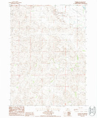
1986 Map of Dunning NE
USGS Topo · Published 1987About this map
N Loup R flows across the northeastern corner of this Sandhills landscape in Blaine County. The terrain is defined by the broad, low expanse of Hawley Flats, where the topography shows a complex network of dunes and depressions typical of central Nebraska. This 1980s provisional survey illustrates the sparse settlement patterns of the region, emphasizing natural drainage and landform over dense development. Human activity is evidenced primarily by section-line roads and a localized Gravel Pit, reflecting the area's reliance on local materials for infrastructure. The map serves as a detailed record of the township boundaries, specifically where T23N and T22N meet, providing a clear view of land divisions in this rural cattle-country environment.
Find a feature on this map
6 named features on this map. Tap any name to fly to it.
Don’t see what you’re looking for? This feature index may not catch every label — zoom into the map to look around manually.
Map Details
Editions of this 1986 Dunning NE Map
This is the sole edition of this map. No revisions or reprints were ever made.
Other maps of this area

1949 · Koshopah
USGS Topo · 1:62,500

1951 · Dunning
USGS Topo · 1:62,500

1951 · Koshopah
USGS Topo · 1:62,500

1952 · Brewster SW
USGS Topo · 1:24,000

1952 · Brewster NW
USGS Topo · 1:24,000

1954 · North Platte
USGS Topo · 1:250,000

1955 · Broken Bow
USGS Topo · 1:250,000

1955 · O'Neill
USGS Topo · 1:250,000

1956 · Broken Bow
USGS Topo · 1:250,000

1956 · North Platte
USGS Topo · 1:250,000